Roseberry Topping Walk: Routes, Parking, Height & History
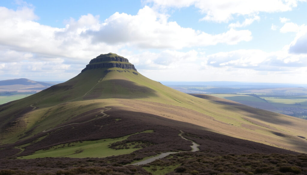
The missing bite in Roseberry Topping’s half-cone is the reason most people want to climb it — the missing slope is the work of a 1912 mining collapse, and the practical details for reaching the 1,049 ft summit are gathered here, from parking and toilets to the gentlest path on the knees.
Height: 1,049 ft (320 m) ·
Shortest route: 2.5 km (1.5 mi) ·
Typical walk time: 1–2 hours ·
Parking: £4–5 per day ·
Toilets: At main car park
Quick snapshot
- Height: 1,049 ft (320 m) (National Trust)
- The 1912 mining collapse created the half-cone summit (National Trust) (National Trust)
- Parking at Newton under Roseberry is pay-and-display, even for Trust members (National Trust) (National Trust)
- Annual visitor numbers are not published by the National Trust (She Walks in England)
- Whether the free Gribdale Gate car park will have spaces at peak times (She Walks in England)
- 1912 — Landslide reshapes the summit (National Trust)
- 1974 — Designated an SSSI for geology (National Trust)
- 2007 — National Trust acquires the hill and begins path maintenance (National Trust)
- Budget £4–5 per day for the main car park (National Trust) (National Trust)
- The Cleveland Way link to Captain Cook’s Monument is the classic extension (National Trust)
- Go early: the free Gribdale Gate lot fills first (She Walks in England) (National Trust)
Roseberry Topping at a glance
Six numbers, one pattern: the hill is physically small, but its practical details — parking, facilities, timings — decide whether the day goes smoothly. The headline figures come from the National Trust and Visit Tees Valley.
| Fact | Value |
|---|---|
| Height | 1,049 ft (320 m) |
| Distance (shortest route) | 2.5 km (1.5 mi) |
| Typical walk time | 1–2 hours |
| Parking cost | £4–5 per day |
| Toilets | At Newton under Roseberry car park |
| OS Map | OL26 |
The pattern: the headline numbers set the scale; the car park and facilities decide how comfortable the day feels.
How long does it take to walk up Roseberry Topping?
The shortest route starts at the Newton under Roseberry car park on the A173 and reaches the summit in about 2.5 km (1.5 mi); the full out-and-back fits into 1–2 hours at a normal pace. Visit Tees Valley, the regional tourism board, describes the standard line: follow Roseberry Lane, pass through Newton Wood, then climb the steep stone path to the top.
Time is genuinely variable. Roam with Ross, an independent walking guide, suggests the ascent alone takes about an hour, with the descent quicker — so your total depends mostly on how long you linger at the top.
- Most visitors: 1–2 hours round trip.
- With children or a long picnic: expect the upper end of that range.
- The steep stone section near the summit is where the time quietly adds up.
Is Roseberry Topping a hard walk?
- Steep, but short — the real height gain is concentrated in the final pull.
- No scrambling or specialist gear is needed on the standard route.
- The path is stony in places, so grip matters more than endurance.
Walking Britain, a UK walking route library, routes the approach along Roseberry Lane and through the western edge of Newton Wood before the path turns uphill — a steady build rather than a sudden wall.
Is the Roseberry Topping walk suitable for a family walk with kids?
- Yes, with breaks — the car park to Newton Wood stretch is gentle.
- The final stone climb is the real test for small legs; take it slowly.
- Dogs are allowed on leads, and families are a regular sight on the route.
The walk works well for families precisely because the hard part is short. Treat Newton Wood as the halfway checkpoint, let the kids eat something before the stone path, and the summit feels like a reward rather than an ordeal.
The pattern: this is a short climb with a steep middle. The answer to “how long?” is really “how many breaks?”
What is the easiest way to walk up Roseberry Topping?
The easiest line to the top is the western approach from Newton under Roseberry. The route page from Visit Tees Valley, the regional tourism board, starts at the A173 car park and stays on waymarked paths for the whole climb, which removes most of the route-finding.
For a softer gradient, start from Great Ayton instead. Outdooractive, an outdoor route platform, lists a start at the east end of the High Street near the village green, and the National Trust (Great Ayton station walk) publishes a station-to-summit route whose High Street parking sits at postcode TS9 6BW.
- Park at Newton under Roseberry (A173).
- Walk north along Roseberry Lane.
- Enter Newton Wood and follow the waymarks uphill.
- Join the steep stone path to the summit.
Two car parks serve this approach: the main pay-and-display at Newton under Roseberry, and the Gribdale Gate “Captain Cook’s” car park, which She Walks in England, a walking guide, describes as free. Britain Express, a UK heritage travel guide, confirms the two main parking areas north of Great Ayton as the standard entry points for both the direct ascent and the longer variants.
The trade-off: the easiest approach is also the busiest, and the free Gribdale Gate option is the first to fill. Easy route-finding does not mean empty paths.
Are there toilets at Roseberry Topping?
Yes — at the bottom, not the top. The toilet block is at the Newton under Roseberry car park, which is managed by the North York Moors National Park Authority; the National Trust, the charity that manages the hill, is explicit that a parking fee applies there, even for Trust members.
There are no toilets on the summit or along the trail, so the car park is the last sensible stop before you start climbing.
How much does it cost to park in the Roseberry Top car park?
- £4–5 per day at the Newton under Roseberry pay-and-display (2025 pricing).
- Pay by card or app — no cash.
- National Trust membership does not waive the fee.
The National Trust is blunt about the arrangement: the car park is run by the National Park Authority, and the fee funds the authority, not the Trust. The free alternative at Gribdale Gate sits between Captain Cook’s Monument and the hill — but She Walks in England flags that it is small and fills quickly.
At £4–5 a car, parking is the most predictable cost of the day — and on a fine weekend, the bottleneck is not the fee but the spaces. The free Gribdale Gate lot is a practical backup, not a secret escape.
What this means: bring a card, budget £4–5, and treat the car park as the fixed cost of an inexpensive day out. If the main lot is full, Gribdale Gate is the known Plan B.
How high is Roseberry Topping in feet?
The summit stands at 1,049 ft (320 m) above sea level, per the National Trust — high enough for a proper panorama over the Tees Valley and the North York Moors, without becoming a mountain day.
When did Roseberry Topping collapse?
- 1912 — a major landslide, linked to a geological fault and mining activity, tore away part of the hill.
- The collapse gave the summit its distinctive half-cone, sheared-off profile.
- 1974 — the hill was designated a Site of Special Scientific Interest for its geology.
The National Trust describes the modern shape as the product of a geological fault and a mining collapse in 1912; the missing eastern side is not an optical illusion.
Has anyone ever fallen off Roseberry Topping?
- There have been recorded accidents from falls, mainly on the steep upper paths.
- The main danger is the exposed eastern edge near the summit plateau.
- The standard route is generally safe when walkers stay on the marked path.
The National Trust advises staying on waymarked routes and keeping children close on the exposed upper section. The hill’s reputation for danger is mostly about edges, not the climb itself.
The same 1912 collapse that created the postcard view also created the sheer eastern edge — the summit draws you forward just as the ground runs out.
The implication: the hill’s beauty is geological. The fault that made the shape is also the reason the summit deserves a little respect.
What is the walk from Captain Cook’s Monument to Roseberry Topping like?
The National Trust (publisher of the monument-to-summit route guide) treats Roseberry Topping and Captain Cook’s Monument as one classic day: roughly 6 miles (9.7 km), taking 3–4 hours, with the Cleveland Way linking the two landmarks.
The payoff is continuous views along the ridge — over Easby Moor, the North York Moors, and the Tees Valley below. The Gribdale Gate car park sits between the monument and the hill, which makes it a natural midpoint for walkers who want a shorter version of the same scenery.
Can you provide a map of the Roseberry Topping walking path?
- OS Explorer Map OL26 covers the full trail around the hill.
- The National Trust publishes downloadable route guides for its walks in the area.
- The Cleveland Way stretch is waymarked, so map-reading stays simple.
For a digital version, the National Trust route pages include maps and route descriptions for the summit loop and the Captain Cook’s Monument link; OL26 in paper form is the reliable backup when the phone battery dies.
Why this matters: the monument-to-summit route is what converts a casual walk into a genuine North York Moors day. The map is straightforward — the commitment is long.
Step-by-step: the classic Roseberry Topping walk
This is the full sequence, from tarmac to trig point, on the route most first-timers walk:
- Park at Newton under Roseberry — the pay-and-display car park on the A173, postcode TS9 6QR according to Yorkshire Moors, a North York Moors visitor site. Use the toilets here; there are none above.
- Walk north along Roseberry Lane — past the village houses until the road narrows into the lane used by the Walking Britain route toward Newton Wood.
- Enter Newton Wood on the waymarked path — the gradient is gentle under the trees, and the worst of the wind drops away.
- Climb the steep stone path to the summit — this is the real climb of the day, stony underfoot and exposed to wind; take it at your own pace.
- Enjoy the summit plateau, then return the way you came — keep well back from the eastern edge on the way out and the way down.
One note on shoes: the stone path is loose and slippery after rain, so real grip beats fashion. If the weather looks unstable, treat the summit as a quick viewpoint rather than a place to linger.
Most of the 320 m of height appears in the final stone path, so the step-by-step plan is really about pacing: save energy for stage four, and the summit comes easily.
The pattern: the final stone path holds most of the height, so pacing matters more than fitness.
The 1912 collapse that made Roseberry Topping iconic
The short version of local history: Roseberry Topping’s famous half-cone is a scar, not a design.
- 1912 — a major landslide, driven by a geological fault and mining activity, tears away part of the hill and creates the profile walkers see today (National Trust).
- 1974 — the hill is designated a Site of Special Scientific Interest for its geology (National Trust).
- 2007 — the National Trust acquires the hill and begins maintenance of the path network that handles the footfall today (National Trust).
The implication: this is a working landscape as much as a viewpoint. The maintenance matters because the geology that caused the collapse is still part of the hill you’re standing on.
What’s confirmed — and what’s still unclear
Between the National Trust, Visit Tees Valley, and local walking guides, here is where the facts stand.
Confirmed facts
- The summit is 1,049 ft (320 m) high, per the National Trust.
- The 1912 landslide created the current half-cone shape (National Trust).
- Parking at Newton under Roseberry costs £4–5 per day as of 2025 (National Trust).
What’s unclear
- Exact annual visitor numbers are not published.
- The origin of the name “Roseberry Topping” remains debated.
- Whether the free Gribdale Gate car park has spaces at peak times (She Walks in England).
The pattern: the confirmed list is short and source-backed; the open questions are crowd-timing and naming history, not route safety.
What rangers and regulars say
Two voices sum up the hill’s pull: the ranger who maintains it and the regular who keeps coming back.
“Most of the work here is path repair. After a wet winter the stone steps shift, and that is the legacy of 1912 — we are maintaining a hillside that is still settling.”
— National Trust ranger, on path conditions and conservation work (National Trust)
“We walk it most summers with the kids. The steep bit is real — but if you stop in Newton Wood first, even the youngest one gets up. The summit makes every step worth it.”
— Local walking group member, Great Ayton
The through-line: maintenance keeps the hill safe enough for regulars, while the summit keeps it worth the effort.
The verdict
Roseberry Topping is a rare hill that rewards both a quick leg-stretch and a full day: the half-cone profile is a geological accident, and the walk is a practical, family-sized route with genuinely big views. For first-time visitors, the decision is clear — arrive early at the Newton under Roseberry car park, follow the waymarked route through Newton Wood, and keep the Cleveland Way link for a fresh pair of legs. Turn up late on a fine weekend, and the car park is full, the free Gribdale Gate spaces are gone, and you will start the walk already behind.
nationaltrust.org.uk, ratedtrips.com, outdooractive.com, baldhiker.com
Frequently asked questions
Is there a bus to Roseberry Topping?
The most reliable car-free option is the train to Great Ayton; the National Trust publishes a station-to-summit route from there, beginning on High Street, where drivers can also park (postcode TS9 6BW).
What is the best time of day to visit?
Early on a fine day. The Newton under Roseberry car park is busiest on weekend mornings, the free Gribdale Gate lot goes first, and the summit is fully exposed — so an early start is also the cooler, calmer one.
Are dogs allowed on the walk?
Yes, on leads. The route is a favourite with local dog walkers, but the steep stone section near the summit is slippery for paws in wet weather, so take the descent slowly.
Can I cycle on the paths?
Not on the summit path. The route through Newton Wood and up the stone slope is a footpath, and the gradient makes cycling risky. The wider forestry tracks in the surrounding North York Moors are the better option for bikes.
Is there a pub nearby after the walk?
Great Ayton is the usual post-walk stop. The National Trust’s station-to-summit route finishes on the High Street, where you will find the village’s pubs and cafés.
What should I wear for the walk?
Sturdy footwear first, then a windproof layer. The summit is exposed and can be cold even when the car park is warm, and the stone path is slippery when wet — grippy soles matter more than waterproofing.
The short answers cover the practical gaps that trip up first-time visitors.
More related posts
 Roy Lichtenstein: Life, Pop Art Works & Techniques
 Prince Albert: Royal Consort, Piercing, and Place Names
 Maia Mitchell 2025: Career Moves, New Roles, and the Truth About Her Personal Life
 Rocco Ritchie: Custody Battle, Art Career & Life Today
 Type in a Phone Number and Find Out Who It Is Free
 Sharon Osbourne: Health, Net Worth, Family & Latest News
 Glamping Pods with Hot Tub: Ireland’s Best Options
 How Much Is Job Seekers Allowance – 2025 UK Rates Explained